
It was just your typical 1335km weekend road trip. While the primary goal was to attend the Southern Alberta Weekend (SAW) which is an annual Geocaching event put on by the South East Alberta Region Cache Hunters (SEARCH). Of course, for us getting there is more than half the fun so we had an interesting route picked out.
Our route took us north of Hanna, which is the completely wrong way to go if one wants to get from our house to Medicine Hat. Our reason for this detour was thanks to a National Film Board video from 1973 called “Every Saturday Night”. If you have time, give it a watch here:
https://www.nfb.ca/film/every_saturday_night/embed/player/
Every Saturday Night, Tom Radford, National Film Board of Canada
In the film, you can see clips of Springwater School, some shots of the community hall at Garden Plain, and some scenes in Dorothy — complete with two elevators in the background, no less! But, it was one shot in particular that caught my attention, and that was of a classic Alberta Wheat Pool elevator in Garden Plain. At least, using context clues from some other scenes in the film we believe it to be Garden Plain. Our mission was to try and locate where this shot was taken.
Alberta Wheat Pool elevator at Garden Plain
The route I planned would take us to the Sharples elevator, the Bleriot Ferry, then to Springwater School, across to St. Peter’s Lutheran Church near Scapa, and then finally to Garden Plain. All in all, that’s a pretty decent road trip when it comes to seeing some abandoned/historical sites.
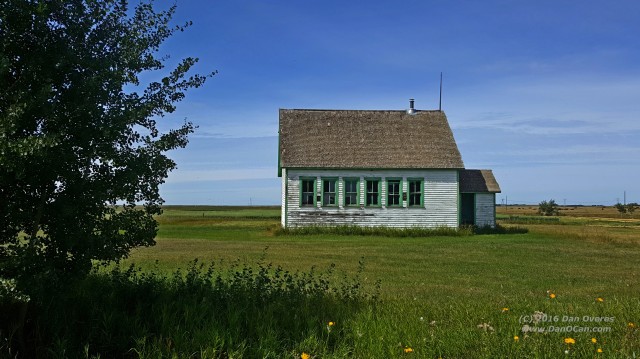
Springwater School is such a unique building. On the inside it looks very much like every other one room schoolhouse which used to dot the prairies, except for the stage at one end. On the outside it is not the simple wood frame construction we are used to seeing. It is built from stone and that undoubtedly is one of the reasons it remains so wonderfully preserved and intact. This was my third visit to Springwater over the last ten years.
St. Peter’s is a place I had only visited once before, that being in July of 2006. I didn’t even remember the proper name for it, so in my conversations with other people I would just refer to it as “a great country church somewhere north of Hanna”. Being able to give it a proper name (and record the coordinates in my Nuvi for future reference) will make things easier from now on. St. Peter’s has a unique story, at least according to the sign out front.
Apparently it was originally built in 1911 up in Wetaskiwin. When that congregation disbanded in 1920, the parishioners dismantled the steeple, cut the church into eight-foot sections, loaded it onto railcars and had it shipped to nearby Craigmyle. From there it was loaded onto sleighs and moved to its current location. That all took place in the winter of 1920-21, which is quite the feat.
So, all that remained was the trip to Garden Plain.
Locating Garden Plain wasn’t that hard to do. Google Maps still claims to know where it was and there was also a Geocache conveniently named “Garden Plain” hidden on the grounds of the community centre. I guess it was a little too easy to find because I failed to do any more detailed research, not even looking closer at Google Maps to determine where the old railway would have run.
When we arrived at Garden Plain Hall, we were struck by the stark contrast between the two sides of the buildings. The north side, which we approached from, has been the recipient of what we dubbed “The Worst Addition/Renovation to a Historic Community Hall Award.” A large metallic Quonset has been tacked onto the side of the building which, while undoubtedly adding valuable space, has ruined the character of the building. Peeking in the windows, we can see it appears to house the kitchen/food preparation space for the community hall.
Our visit was limited to looking in windows, as the building itself was secure and locked. Fortunately, the south side was not expanded so it retains the look of a typical community hall from the turn of the last century. There also was a small playground space that once housed a swingset, but only a few strands of rope remained. Overgrown grass and a microwave haphazardly disposed of in a trash barrel complete the look of a building that doesn’t see The Badlanders play dances here “every Saturday night” any longer.
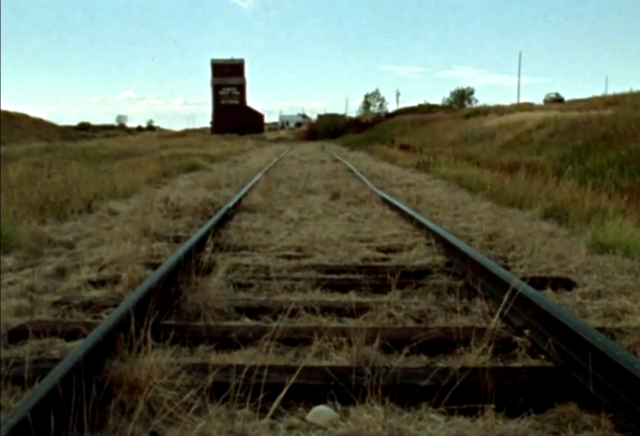
With our tour of Garden Plain Hall complete, we set out to see if we can find where the elevator once stood. Armed with nothing more than a black and white printout of the screenshot from the film, we head east along a grid road towards the spot Google Maps shows the town’s name.
We are immediately encouraged because almost immediately we spot the telltale signs of an old railbed. While the tracks were removed years before, we can easily see the path the tracks would have cut across the prairies. Right on! The tracks were running in a southeast/northwest alignment at this point which perfectly jived with what Google Maps had told me about the location of the town. I keep saying “town”, but I honestly don’t know if Garden Plain ever amounted to much more than an elevator.
We come to the first grid road heading south. “Road” might be a bit of a misnomer as it was more dirt than anything else. Road conditions were dry so our Rondo should have been able to navigate it with no concerns, but the topo map on my handheld GPSr showed the town as being one more road to the east. In what proved to be a misguided move, I turned around and headed back to the north and then continued on to the east.
At the next grid road we once again aimed south. If I had done better research before leaving home, we should have been paying attention and looking for the old railbed along this stretch as the track alignment turned east not long after the spot we had last see it. Not know this, we didn’t think we would intercept the railbed until we got to the next grid road a couple miles south of where we were.
The handheld GPSr slowly swung around and showed Garden Plain off to our right (west). That dirt road I bailed out on certainly appeared to be our best chance of finding the right spot, but now the fuel in the Rondo’s tank was getting low and we still had a fair distance to cover to get to Hanna and civilization. We had to make the tough choice to put an end to this expedition and try again some other time.
On our way to Hanna, we discovered a couple other hidden gems we didn’t know about. One was the Netherby Cemetery and the other was an old schoolhouse just north of there. The school appeared to be on private property and in a manicured corner of the yard so we didn’t explore it but instead just took photos from the road. With time and fuel running short, both the school and cemetery would need to wait for a future trip.

Netherby Cemetery
Netherby (?) School
The rest of our day was uneventful. We made it to Cactus Corner near Hanna before the low fuel light came on, had our ham sandwiches, and then continued on to Medicine Hat where we spent the rest of the weekend. Some of those details will be coming up in a future post.


Bravo, excellent! That NFB flick had me wondering about Garden Plain too, a place I never heard of before. Thanks, great write up, mighty fine photos. The Badlanders would be proud (except for the drummer, he’s too drunk).
LikeLiked by 1 person
Great post, and great find with that video! A real piece of prairie history. Too bad you had to cut your expedition short, it would have been interesting to see if there was anything left of the elevator at Garden Plain.
LikeLiked by 1 person
I’m sure a return trip to Garden Plain will be in my future. I would really love to find where that elevator was!
LikeLike
Interesting read.
LikeLiked by 1 person
Pingback: 2016 In Review: Explorations, Visitations, and Tribulations (Part 2) | DanOCan
Hello, very interesting post regarding Garden Plain. This is the first time I have seen a photo of the actual tracks of the CN rail line between Hemaruka and Scapa. I read somewhere that this length of track was never brought up to optimum operating condition (whatever that means) and this rail line only saw construction trains. While visiting the province this past summer (July of 2017), I went on an expedition to the Special Areas to see what was left of Spondin and Garden Plain. I found Spondin without too much trouble while Garden Plain took some seating to locate. I managed to find what I believe to be the Garden Plain townsite, 3 abandoned and dilapidated buildings near the empty embankment of the former CN rail line. If I wasn’t living so far away, i could show you the photos that I took of this trip.
LikeLike
I would love any information you might be able to share in terms of the location. We struck out so badly in trying to locate it and I still want to make a return trip one day.
LikeLike
Stumbled onto your post and found it interesting. I grew up 12 miles east of Garden Plain in the Spondin area, so I know that area fairly well, my dad and grandpa used to go there for coal, there was some mines close around Garden Plain. Went to several functions in the old hall, a bit of a trip down memory lane!
I do remember the elevator location and it being moved out of Spondin, but not certain on the one at Garden Plain.
LikeLike
Do you remember when the elevator at Sponsin was moved? Curious if it still exists somewhere or if it met the same fate as so many others.
LikeLike
Pingback: The Badlanders | DanOCan
Very interesting.My Father was born in Garden Plain March 1, 1914 to Christian and Mary (Schocenmaier) Schneider.His older brother ,Albert drown in a reseviour at the age of 6 or 7.My Dad went back there in the 1980 s’ , never could find the cementary
LikeLike