One-Room Schoolhouse Road Trip Flashback

It’s been a long time since I last did any updates.  There has been a lot going on which means there has been little time to write anything.  So, rather than continue the silence I decided to revisit some old photos.

Old schools are some of my favorite abandoned buildings and in late September of 2008 I made a road trip through the foothills west of Nanton, Alberta and captured three classic prairie schools.

https://flic.kr/p/5qQRUh

https://flic.kr/p/5qQMEU

https://flic.kr/p/5qQKzh

All images were shot from the road.  All schools were on private property and thus no additional exploration was possible.

Posted in History | Tagged , , , | 1 Comment

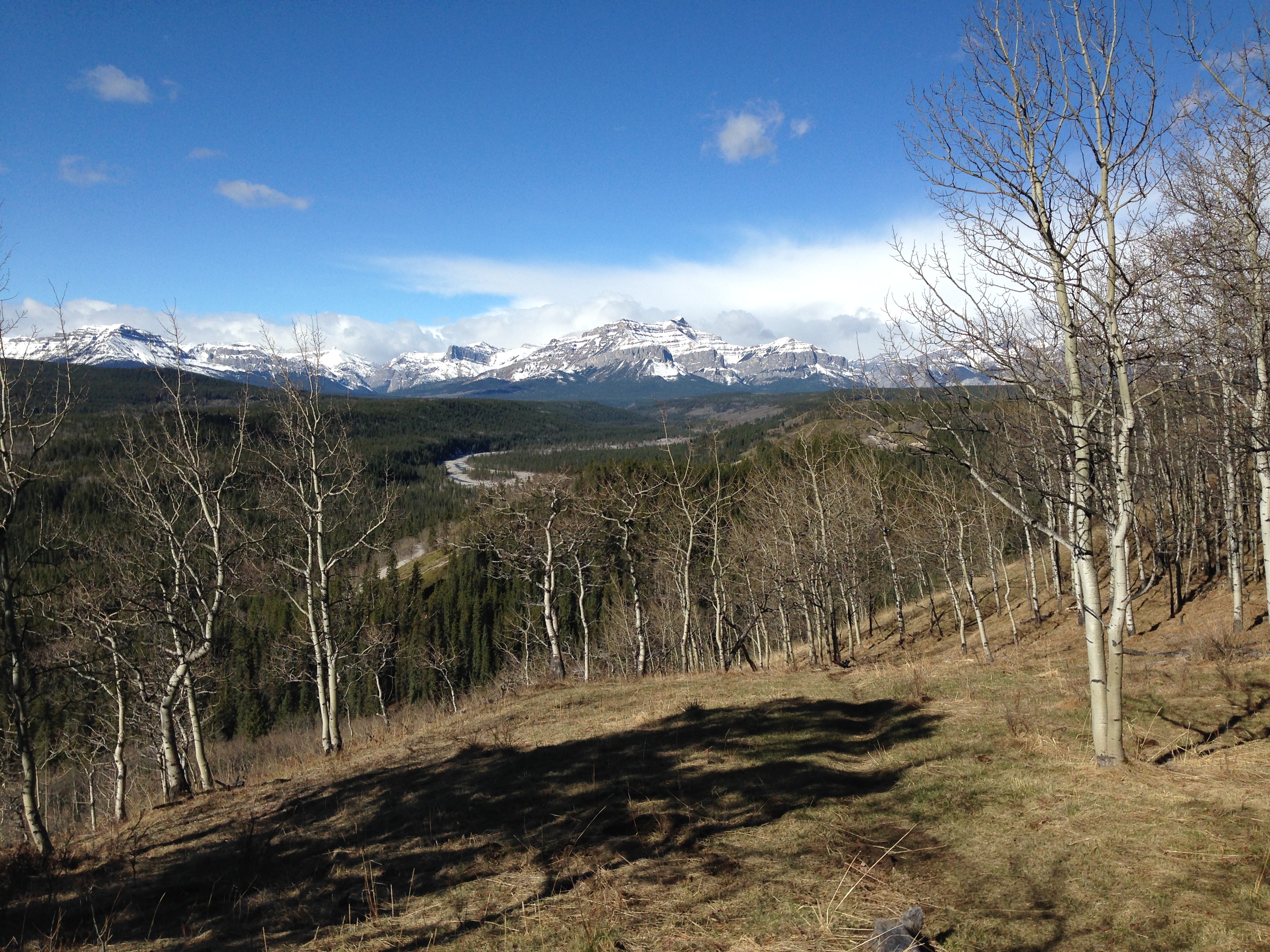
I’ve never hiked Lesueur Ridge before.  Actually, until recently, I had never even heard of it.  But, lured by the prospect of a snow-free ridge walk offering great views of the front range of the Rockies, I decided yesterday was the day to give it a shot.

The trailhead is located approximately 40km from Cochrane.  Follow Highway 1A west until you reach Highway 40 aka the Forestry Trunk Road.  From there you turn north and follow the road past the village of Waiparous.  Just beyond where the pavement ends and Capture the Flag paintball, you turn west along what is known locally as TransAlta Road.  The trailhead is approximately 3km down this rough but easily passable road.  No need for a four wheel drive to get here.  There is ample room for parking.  Set your GPSr for N51° 15.953′ W114° 57.985′ and you should be fine.

It was sunny and 8 Celsius when I reached the trailhead around 10:00.

The trail is easily visible and heads off to the north, following the barbed wire fence.  After about 300m, the fence and the trail turn to your right and you will start moving in a northeasterly direction.  This is where you encounter your first real elevation gain.  Another 300m or so and you’ll reach a plateau.  This will be your first real opportunity to get a good look at the mountains to the west.

You’ll also see a trail heading to the west.  I recommend not following it and instead continue straight ahead to the north.  Not only will doing the loop in a counter-clockwise direction allow you to gain the elevation over a series of summits, but it will keep those great views in front of you as you climb, rather than behind your back the whole way.
The trail heading west here is the one we'll come back on as we complete the loop.

The trail heading west here is the one we’ll come back on as we complete the loop.  

You will follow the ridge and mainly be working your way northwest.  There are a series of uphill sections and false summits, but the wonderful views of the valley and the mountains will be your continuing reward for the grunt effort.

After about 3 – 3.5km, you will finally reach the true summit of the ridge and more views.  If you follow one of the side paths you may even discover a lean-to someone has built.  The wind was rather strong when I was here so I considered using the lean-to as a shelter while taking a water break, but opted to go a little further down the trail first.

After reaching the high point of the ridge, you can either return the way you came or continue and make a loop.  I opted to venture on.  The trail starts to move in a mostly northern direction here, with minimal elevation change.  You can tell most people must turn around, because the trail is narrower and more overgrown.  You start to feel like you are really far away from civilization at this point.

It’s a feeling that only lasts for about 600m or so.  Soon you will emerge on a cutline.  Turn to your left (west) and start down.  You’ll loose almost all of the elevation you gained in just over 1km of hiking.  The cutline appears to be used by dirtbikers on a regular basis, although I didn’t encounter anyone else on my trip.  If you didn’t follow my advice and decided to do the loop in a clockwise direction instead, this is where you’ll do all your ascent — a grunt up a boring cutline with no views to speak of.

When you get down to the bottom, you will come to a simple creek crossing.  I knew this is where I wanted to turn to the south and follow the creek.  My trail maps showed a trail, but I never found it.  I suspect if I had carried on a bit more to the west I would have come across it.  My guess is the trail maps in my GPSr were transcribed from a paper map and thus the trail I was looking for didn’t quite appear in the proper place on my unit.

Nonetheless, the going was fairly easy and I knew I only had about 300m of distance to cover before I would run into Lesueur Creek and the main trail again.  At this point I was hit with a light snow squall that moved through the area.  I was quite fortunate that it quickly passed overhead to the SE and I was soon back in sunshine again.  For a moment I thought it was going to be a wet walk back to the car.

This part of the hike is the most boring.  It’s about 3km back to the plateau where we made the decision to do the loop counter-clockwise.  If you’re in bad shape like me, your legs will appreciate the break from all the ascent/descent you’ve done to get here.

Following the trail back along the creek towards the car.
Following the trail back along the creek towards the car.

Looking north towards the ridge

Looking north towards the ridge — it wasn’t long ago I was standing up there.

The trail will eventually leave the creekbed and follow along the lower part of the ridge.  You’ll get plenty of chances to look up and see the spots you had been standing earlier.  Eventually you’ll come back to the plateau and you’ll do the final descent and then the short walk back to the trailhead.

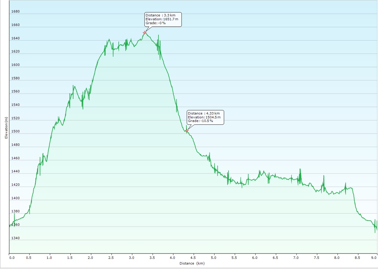
My track log shows my loop was about 9km long, with a net elevation gain of approximately 300m.  My total ascent was closer to 450m, with all the up and down along the ridge.  Total trip time for me was only three hours, including all the stops I did for Geocaching and with plenty of “breath catchers” on the way up.

Elevation Profile

My Elevation Profile

Posted in Hiking | Tagged , , | 2 Comments

Following the Old Macleod Trail

Say “Macleod Trail” to someone in Alberta, and most people will immediately think of the busy commercial strip on the south side of Calgary.  Fewer people will think of the Macleod Trails which are located in a number of smaller communities such as High River.  Ever fewer will think of the original Macleod Trail which was the pathway from Fort Benton, Montana through to Fort Calgary in the 1870’s.

There is a wonderful article detailing the history of this trail and the markers which show the way here:  http://www.highrivertimes.com/2013/06/13/marking-the-historic-macleod-trail

It is through the efforts of the volunteers like Bill Dunn of Cayley, AB that I was able to take a “creative” route down to Lethbridge last weekend when visiting friends and family.

Starting in De Winton, I headed south through the towns of Okotoks and High River before getting out into the more rural markers.  Staying to the west of Highway 2, I picked my way along mostly gravel roads, with the next marker’s coordinates entered into my Nuvi.  I would pass a grain elevator (and see the ones in Nanton off in the distance), abandoned barns and homesteads, the Pine Coulee reservoir, and even the occasional car.

The outcome of that trip is a photo essay which shows the Alberta prairies in all their Spring splendor.  While I would run out of sunlight before getting to see all the markers, that just means there is another adventure waiting for another trip.  This trip only covered the markers I found between De Winton and Claresholm.

Posted in History | Tagged , , , | 9 Comments

New Heritage Marker Unveiled in Big Valley

We were very fortunate that we stumbled across a member of the Big Valley Heritage Society while touring around the town last month. She was very passionate about the church and was more than happy to get a key and open it up so she could show us the inside. That sort of passion is such a rare thing, it seems. Sometimes when you spend so much time with people who are passionate about history you forget the general public is often not even aware. I’m glad to see the government supporting our local heritage through the use of informational signs such as this one.

editor, RETROactive's avatarRETROactive

On Friday, August 1, 2014 another heritage maker was unveiled to join the family of over 70 provincial markers located throughout Alberta. Situated in Big Valley, the heritage marker profiles the early history and architectural significance of a prominent local landmark – the St. Edmund’s Anglican Church.

The unveiling of the St. Edmund’s heritage marker coincided with the Big Valley centennial and homecoming celebrations that took place August 1 – 3, 2014. L to R: Gail Knudson, Mayor of Big Valley; Asaph Johnson, Village Councillor; Brenda Manweiler, Historic Places Research and Designation; Lois Miller, Village Councillor and Director, Big Valley Historical Society; Trudy Spence, Secretary, Big Valley Historical Society The unveiling of the St. Edmund’s heritage marker coincided with the Big Valley centennial and homecoming celebrations that took place August 1 – 3, 2014.
L to R: Gail Knudson, Mayor of Big Valley; Asaph Johnson, Village Councillor; Brenda Manweiler, Historic Places Research and Designation; Lois Miller, Village Councillor and Director, Big Valley Historical Society; Trudy Spence, Secretary, Big Valley Historical Society

St. Edmund’s, valued by residents of Big Valley as an important part of their heritage, was constructed in 1916 through local donations and a $500 contribution from English citizen Caroline Leffler. Leffler offered the donation to the Bishop of the Anglican…

View original post 211 more words

Posted in History | Leave a comment

July 2014: What a Month!

The sad irony of trying to be a blogger is the more interesting things going on to write about, the less time there is to actually write any of it down.  As we approach the unofficial halfway point of summer, it’s hard to believe just how much activity I squeezed into July.  I guess having the bulk of the month off for vacation helped a lot as I didn’t have that annoying work thing getting in my way.

There was the Stampede parade, seeing Blue Rodeo in concert, the mini ghost town tour of southern Alberta, the exploration of Big Valley and Rowley, the drive to Saskatoon and then on to Yorkton for the eighth annual Ghost Town Convention (GTC), the drive back to Saskatoon, exploring the area around Lake Diefenbaker, Geocaching and Geocaching events, coming back home to Cochrane and then hitting Calaway Park for the first time in nearly 25 years, and I’ve attended a couple events for Historic Calgary Week.  All that and I’ve even managed to be back at work for a full week now.

I really wish I could take the time to write it all down every night, to properly capture the feelings and document the experiences.  There simply isn’t time so I have to rely on a series of quickly composed Facebook status updates to look back on.

Here’s some of the highlights of what July looked like as captured via my iPhone’s photo stream.

Posted in Geocaching, History, Travel | Leave a comment