Back in October of 2023, I saw a post on Facebook from Chinook Country Historical Society which mentioned a couple of researchers from Alberta University of the Arts were conducting a study on the practices of placing expired license plates on garage walls.
I contacted the researchers and volunteered. Initially I was told they wanted to focus on people closer to downtown Calgary but a few months later I was contacted and asked if I was still interested in participating. I certainly was!
The interview took place in May of 2024. Ian Fitzgerald (lead researcher) and Scott Cressman (co-researcher) came out to my place in Cochrane and we spent a good hour or more talking about my license plates and reasons why I collect them.
The results of their research resulted in a video which premiered in November of last year at SAIT. The other participants and I were invited to attend the screening and then sit on a live panel afterwards to field questions from the audience, which mostly consisted of art students attending AUArts.
This was a great experience and a lot of fun, right from the initial interview through the final presentation. A couple weeks ago I asked them if the video was available online anywhere and they sent me the link to the video on Scott’s YouTube page. It is unlisted (which is why I wasn’t able to find it anywhere by searching) so I hope they don’t mind if I share it here. I think this was a fascinating project and I would love more people to see it.
Sandon is probably one of the most popular ghost towns in the entire province of British Columbia. It’s a must-do for any fan of historic places so we knew we would love it and we finally made it here to see for ourselves.
Sandon is nestled in the Selkirk Mountains, about 13km east of New Denver in the Slocan Valley.
Sandon’s history can be traced back to two prospectors: Eli Carpenter and John Seaton. In 1891, while initially searching for silver together, they eventually split up for their return journey. It was during this time Carpenter found what became known as the Payne vein. Seaton staked his own claim for what became the Noble Five Mine. By 1892, Sandon was founded to support all the prospecting and mining taking place in the area. The valley proved to be a rich source of silver, lead, and zinc, with the area becoming known as “The Silvery Slocan”.
By 1898, Sandon was officially incorporated as a city, boasting modern amenities and a population of around 5000, although some sources go as high as 10,000.
Sandon’s boomtown status was short-lived. On May 3, 1900, a devastating fire tore through the town’s commercial district, destroying around 50 buildings. Although some rebuilding took place, silver prices were already on a downward trend. Combined with labour disputes and rising operational costs, many investors chose to take their money elsewhere. This marked the beginning of the end for Sandon as a thriving western mining town.
Sandon City Hall, built in 1900 as part of the town’s post-fire reconstruction, once served as a town hall, jail, fire hall, and courthouse. Today, it houses The Prospector’s Pick visitor centre.
Sandon was serviced by two competing railways: the Kaslo & Slocan (K&S), backed by the Great Northern Railway, and the Nakusp & Slocan (N&S), operated by the Canadian Pacific Railway. The fact that two rival lines built spur routes into a remote, dead-end valley was virtually unprecedented—highlighting Sandon’s immense importance during the height of the silver boom. The K&S had a more direct approach from the east, while the N&S came from the west and faced steeper grades and more challenging terrain, particularly near Sandon.
Canadian Pacific Railway (CPR) Locomotive #6947, originally built in September 1908 by Montreal Locomotive Works
Both railways faced infrastructure challenges due to steep terrain, fires, and frequent washouts. As silver prices declined and road transportation gained prominence, both lines reduced service. The Kaslo & Slocan Railway ran its last commercial train from Sandon in 1908. While the exact date of the Nakusp & Slocan Railway’s final operations into Sandon is unclear, service declined steadily through the mid-20th century and was effectively ended by the 1955 flood.
Carpenter Creek flooded in 1955 and wiped out many of the remaining buildings and, what the creek didn’t take, was soon removed by looters and souvenir seekers. Today a few buildings remain, the most impressive being the old Town Hall, which was built in 1900, likely as part of the post-fire reconstruction. Like many municipal buildings of that era, it served many purposes — town hall, jail, fire hall, and courthouse. Today it houses The Prospector’s Pick, which functions as Sandon’s visitor centre and gift shop.
Also remaining is the Silversmith Power and Light station, which uses the water from Carpenter Creek to turn a Pelton wheel which in turn runs an original Westinghouse generator built to Nikola Tesla’s 60Hz AC specifications and has been in operation since 1897. While originally built to power the Slocan Star Mine, today it feeds into the BC Hydro power grid, bringing electricity to Sandon as well as New Denver and others.
Today, Sandon isn’t just about the remnants of a mining boom town—it’s also home to a fleet of mid-20th century Brill trolley buses. These electric buses were built by Canadian Car and Foundry under license from ACF-Brill Motors Company of Philadelphia. From the late 1940s through the early 1980s, they formed the backbone of Vancouver’s public transit system.
Destined for the scrap heap, Hal Wright—Sandon’s caretaker—stepped in and relocated 13 of them to the town in 2001. The plan was to refurbish the buses and eventually distribute them to transit museums. Of course, that kind of restoration takes serious funding, and the buses have remained in Sandon ever since, becoming a tourist attraction in their own right.
Dan and Emily in Sandon (September 2025)
And, of course, we have to add a couple of bonuses to our visit — we drive further up the valley to see the site of the ghost town of Cody and then we visit the often overlooked Sandon cemetery too.
At least one source online mentions this as the former train station in Cody, BC.Cody, BC – photo by Dan Overes (September 2025)
On August 30th, 2025 my friend Harry and I hiked up Mount Burke in Kananaskis Country to explore one of Alberta’s most fascinating relics — the abandoned Cameron fire lookout.
This video captures the full journey: from the forested switchbacks to the exposed summit, where the wind howls and history lingers. Built in 1929 by the Alberta Forest Service, the Cameron lookout was once the highest fire lookout in Canada, perched at over 2,500 meters. It operated until 1953, when newer stations on Raspberry Ridge and Hailstone Butte took over. Today, it stands empty — a weathered sentinel clinging to the edge of the mountain, still grounded by a steel cable that runs down to the treeline. That cable wasn’t just for stability — it was meant to protect the lookout from lightning strikes by grounding it in moist earth.
There’s even a wild story about one ranger who fled the mountain in just boots and long underwear after lightning blew up his bed during a storm. Alberta weather doesn’t mess around.
If you search for “Ronalane” using Google Maps, you will find yourself looking at a dot in the middle of an empty prairie landscape. But, zoom out a bit. What do you see? Large tracts of undeveloped land, set next to a picturesque s-curve in the Bow River. Seems like a place with a lot of potential, doesn’t it?
That is exactly what J.D. McGregor thought too. McGregor was a rancher who spent many days tracking down wandering cattle in this area. He felt that if there was a way to bring irrigation to this semi-arid land, the potential for growth was huge.
McGregor pitched the idea to some wealthy financiers in Britian and thus the Southern Alberta Land Company was created. The Company purchased 400,000 acres of land with the plan of bringing irrigation to the area. At the time, it was thought that it took 35 acres of grassland to raise one steer. With irrigation, the plan was to flip this ratio and instead raise 35 steer per acre.
McGregor became the managing director of the company and Ronald Lane was brought in as President. With the framework in place, they hired Arthur Grace as chief engineer who was tasked with conducting the survey of the land.
Grace determined the best place to intake water for the project was by Johnson Island near Carseland, Alberta. A combination of earthen and concrete dam was constructed to raise the water level the 12 feet it was determined would be needed. This would be the start of the project which became known as the “Big Ditch”.
Along the way, more engineering challenges awaited the team. The geography necessitated “the big cut”, which was a 64 foot deep, 1.75 mile long excavation to carry water through the natural barrier presented by the banks of the Bow River. This required the removal of 1,500,000 cubic yards of earth.
The Company also constructed two additional dams in the Snake Valley, which would eventually bring about the creation of Lake McGregor. This reservoir remains a much-loved recreational site for southern Albertans to this day, in addition to its primary irrigation function.
These were remarkable achievements considering this was the era of steam shovels. The Company had to import mules from St. Louis, MO because there were not enough horses in the area. While the Dominion Land Survey had outlined a series of road allowances back in the 1870s, no roads had yet been constructed. The Company was contractually obligated to build and maintain a bridge every place their canal crossed a road allowance. Approximately 80 such bridges were built.
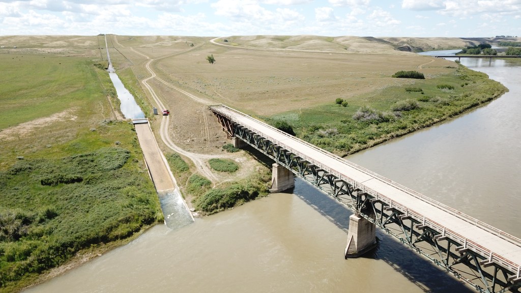
We eventually get to the area around Ronalane. To get the canal from the west side of the Bow to the east, the Company planned to build a gigantic siphon. The siphon would be carried by a new bridge which would also be designed to carry vehicular traffic. Five spans set on concrete piers were required. The Company also planned on a railway running through the area from Suffield all the way to Lethbridge, a portion of which ended up being built by the Canadian Pacific Railway.
The Company laid out plans for several towns along the rail route, the crown jewel being Ronalane, named for the President of the Southern Alberta Land Company. They felt they could use the energy of the water in the siphon to generate electricity for the town. Thanks to large deposits of natural gas, they also planned on delivering gas to each home, along with a sewer system. This was very advanced stuff back in 1912! They even planned on eventually running an inter-city electric railway across the Ronalane Bridge.
However, it was not to be. Traversing approximately 119 miles meant there was a lot of water loss due to evaporation and seepage. The outbreak of World War One also stalled the project. Massive drought meant many farmers in the area were forced to surrender their lands. The project stalled and was eventually abandoned by 1914.
Eventually the assets of the Southern Alberta Land Company were acquired by the Canadian government. Some of the project’s work still remains in place, such as Lake McGregor mentioned above. Also remaining intact is the Ronalane Bridge.
The old Ronalane Bridge – June 29, 2025
The bridge never did carry the siphon across the Bow. To the east of the bridge you can still see the concrete cradles which had been constructed to support the siphon. You can also see where the canal was dug for many miles, extending off to the horizon. However, the canal was never constructed east of the Bow at Ronalane. The canal has been sitting there dry for over one hundred years now. Discussions took place for many decades afterwards about whether or not to complete the project, but nothing ever happened. The planned towns, including Ronalane, remain just unincorporated place names on the map, although you can see the railbed still on the satellite images.
The canal which was constructed but never used is still visible on the east side of the bridge.The concrete cradles still sit waiting to support the siphon which was never constructed.
As for the Ronalane Bridge, it was apparently damaged in the 1950s and required massive reconstruction. It remained in use for several decades until Highway 524 was eventually realigned and new bridge was constucted further upstream on the Bow. Today the old Ronalane bridge still spans the Bow River, but it is blockaded at both ends and the wooden approaches are rotting away.
The west approach to the Ronalane Bridge is blocked off.The wooden approaches are showing significant signs of decay. Venturing out onto the bridge is not advised (and very likely illegal too!)The realigned highway and new bridge are visible at the top of this photo.
If you want to see the video I made of our trip to the Ronalane Bridge, you can click below:
Sources
•Alberta Register of Historic Places. (n.d.). In Alberta Register of Historic Places.
•Calgary Herald. (1912, September 17). Calgary Herald – Tuesday, September 17, 1912.
•Gershaw, F. W. (2018, January 18). History: Railways and irrigation. Canadian Cattlemen.
In the world of historic grain elevators, good news is rare. If an elevator makes the news, it usually means it was either destroyed by fire or demolished. But today, we bring you a success story: the iconic grain elevator in Dorothy, Alberta is being restored.
Built in 1928 by the Alberta Pacific Grain Company, most sources agree the elevator remained in use until 1951. Since then, it has sat deteriorating. A windstorm in the summer of 2015 ripped the roof off the cupola, and it looked like that might be the final straw for this prairie sentinel.
Grain elevator at Dorothy, Alberta (July 2, 2017)Drone photo showing inside of 1928 Alberta Pacific Grain Company elevator (May 30, 2020)
However, against all odds, funding was secured and restoration work began in April of this year. Since then, the structure has been stabilized, a new roof added, missing panels replaced using parts from a donor elevator in Saskatchewan, and a fresh coat of paint was being applied at the time of our visit.
After appearing in advertisements, Tom Cochrane’s music video for Life is a Highway, and even a cameo in Ghostbusters: Afterlife, the Dorothy grain elevator has been brought back from the brink—and is set to stand tall against the prairie sky for years to come.