End of the Line for Calgary’s Oldest Service Station

“You know the place, even if you never actually purchased fuel from its two outdated pumps, or bought coffee or lottery tickets over the counter inside.” — Michael Platt, Calgary Sun

It is a story we see play out again and again when it comes to historical preservation.  A piece of our past is put up for sale and purchased by a developer with a vision for something bigger, better, newer.  Some will come forward and argue for preservation or re purposing, while others will chant “Progress!”.

When you’re making the case for preservation, it’s a fight you will almost always lose.  Dollars and sense are all that matter in today’s world.  Try and find an investor who would be willing to spend the money on remediation of the site, of renovating the building, of trying to start some sort of small business — good luck.  That’s a lot of investment with little return on a large amount of risk.  But, find someone with the money to knock it down and build another generic highrise?  No problem.  After all, high priced condos over main floor retail?  That’s a recipe for making money.  And, it can all be done in the name of urban revitalization too!

And, when that little nondescript building you want to see saved is a gas station in Calgary?  Forget it.  First of all, gas stations are used for cars and today Calgary is all about trying to shed its image as a car capital.  We’re actively taking away lanes from cars and giving them to bicycles.  We’re intentionally making fewer and fewer places to park.  Cars are evil now.

pa-3837-24

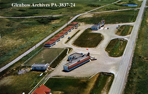
Eamon’s Service Station – June 10, 1956 http://ww2.glenbow.org/dbimages/arcpa/2/g/pa-3837-24.jpg

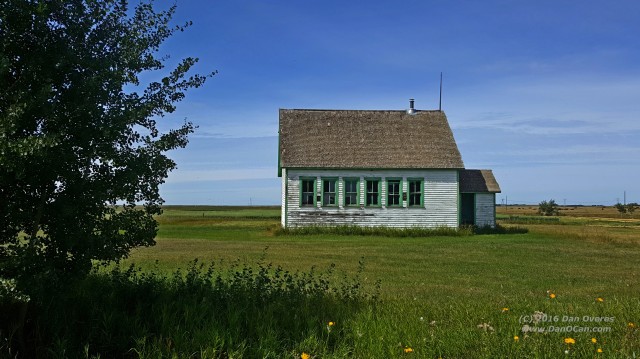
Second, Calgary will live with the legacy of the Eamon’s Service Station fiasco for many years to come.  For those who need a refresher, Eamon’s was a local landmark located on the old highway (now the 1A) between Calgary and Banff.  It was your typical postwar roadside oasis, complete with gas station, restaurant, and cabins.  It was Calgary’s own little Route 66 style stopping place.

When the City needed the land to build the Tuscany light rail transit (LRT) station, they tried to do the right thing.  They purchased the sign and the gas station building and put them into storage, and then waited for an entrepreneur type to come along with a grand vision.  Convert the station into a small cafe or coffee house and then re-open it near the original site.  Sounds perfect, right?  Morning commuters could grab a coffee and a muffin on their way to the train and we preserved the history of this local icon in a useful and meaningful way.

It never happened.  No one came forward with cash and a viable plan.

So, the little service station continued to sit in storage, costing Calgary taxpayers money every month.

Sure, the City eventually took the historic sign and put in close to the original location in the parking lot of the new train station.  It stands there today as an out-of-context stark reminder of what was there.

The building was eventually sold to a car club in High River, AB for $10 and moved to their grounds where it sits awaiting restoration.  It will be many years before local preservationists will escape the shadow of the Eamon’s legacy.  It cost the City of Calgary a lot of money to try and do the right thing.

20160618_140227

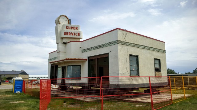
Eamon’s Service Station – June 18, 2016 High River, AB

So, it should come as no surprise that no local politician would dare even suggest doing something to re purpose the little 1952 gas station sitting at the corner of 8th Avenue and 4th Street SE.  It would be career suicide to suggest anything other than “Tear it down and build something shiny.”

service-station

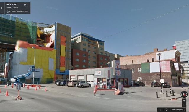
Can Pro Gas and Propane Image from Google Street View (May 2015)

It doesn’t look like much.  It’s small and very typical for service stations of that period.  One rounded corner where the main entrance is located, some service bays, and a couple of pumps sitting diagonally relative to the street.  The owners, having held out for a number of years even as the entire neighborhood around them underwent massive changes, finally deciding it is time to move on.

Perhaps the oldest service station in the city, it is representative of a different era.  Service stations have undergone a lot of change.  Now “service” is a bit of a misnomer.  Pull up to the pump, insert your card, get your gas, and move on.  You don’t even need to see another human in order to get your fuel anymore.  Long gone are the days when a uniformed attendant would appear as you rolled to a stop, start filling your tank, checking your oil, and cleaning your windows.

Our relationships with service stations have changed.  They once represented the freedom of travel that came with the era following World War II.  They meant something; they were special places.  None of this really occurred to me until I started doing an online search of the Glenbow Archives.  I was hoping to find an image of this little service station when it was new and known as the “Transport Service Centre”.

My first search using the subject “Automobiles – Service stations” with keyword “Calgary” was limited to the years 1950 – 1959.  It returned 79 results, mostly of Imperial Oil / Esso stations.  (As a side note, Esso seemed to do the best job of capturing their stations.)  None of the images I found contained the doomed gas station which is the subject of this post, however.

Changing the search parameters to focus on the years 1960 – 1969 and now there are only 34 images found, less than half of what there were from the 1950s.  Change the years to be from 1970 – 1979 and suddenly there are only four images returned.  This sudden and rapid decrease in the historical record reflects our changing attitude.  Service stations were no seen as vital stopping points as we explored our continent on summer vacations but were rather just another piece of infrastructure and certainly not worth capturing on film.

Of course, I wouldn’t want this article to be a complete downer, so I’ll mention some success stories when it comes to old service stations.  Re-purposing can be done successfully, just perhaps not in Calgary and not right now.

First, Big John’s Texas BBQ in Page, Arizona is a restaurant operating out of an old service station.

john

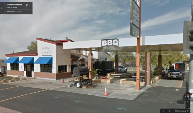
Big John’s BBQ — Page, Arizona Image from Google Street View

This slideshow requires JavaScript.


Posted in History | Tagged , , , , , | 7 Comments

Clarendon Hotel in Gull Lake, SK Destroyed by Fire

“It’s been happening with depressing regularity over the years — another century-old small town hotel has been hit by fire.”  — CBC News

0940

Smiley’s Gateway Hotel on fire in High River, Alberta (November 28, 2005)


It’s a trend that DanOCan.com has noticed.  And, I have been making a special effort to take the time to photograph these classic prairie hotels knowing they are disappearing every year.  Many of them are not exactly photogenic as they have been the victims of some truly horrible renovations over the years, but the history they hold inside their walls remains, regardless of how many layers of stucco have been added.

They can be found everywhere.  Even in our largest cities, these turn-of-the-last-century throwbacks could  be found.  As an example, the now long-gone Cecil Hotel in Calgary, which many were happy to see demolished, stood as a reminder to an era when the railroad was king and the horseless carriage was on the brink of revolutionizing the west.

On Sunday, October 9, the Clarendon Hotel in Gull Lake, Saskatchewan became the latest historic prairie hotel to fall to the flames.  We had a chance to photograph the hotel in July of 2013.

Below are a selection of photos I have taken of prairie hotels — and I will continue to make an effort to capture more of them as we pass through.  Maybe even stop in for a bite to eat and have a drink and meet some of the locals who keep these watering holes alive.

This slideshow requires JavaScript.


Posted in History | Tagged , , , , , , , , , , , , , , , , , , , , , , , , , | 2 Comments

Fire Destroys Spring Valley Grain Elevator – DiscoverMooseJaw.com

How many times have you driven past something and said “I’d really like to get a photo of that one day?  We always think there will be another chance, another day.  Sometimes there isn’t going to be another chance.  That’s the case for anyone who ever drove past the grain elevator in Spring Valley, SK or — even worse — never detoured off the highway to see it in the first place.

A fire broke out in the grain elevator of Spring Valley, Saskatchewan sometime in the evening of August 24th and completely destroyed the building. Carloyn Message, who witnessed the blaze and whose husband is apart of the volunteer fire department…

Source: Fire Destroys Spring Valley Grain Elevator – DiscoverMooseJaw.com

Photograph and document what you can when you have a chance.  Don’t wait for a day when you might have more time, or the light might be better, or you might have a better camera with you.

Time waits for no one.

Spring Valley

Posted in History, Photography | Tagged , , , , , | 6 Comments

Journey to Garden Plain

It was just your typical 1335km weekend road trip.  While the primary goal was to attend the Southern Alberta Weekend (SAW) which is an annual Geocaching event put on by the South East Alberta Region Cache Hunters (SEARCH).  Of course, for us getting there is more than half the fun so we had an interesting route picked out.

Our route took us north of Hanna, which is the completely wrong way to go if one wants to get from our house to Medicine Hat.  Our reason for this detour was thanks to a National Film Board video from 1973 called “Every Saturday Night”.  If you have time, give it a watch here:

https://www.nfb.ca/film/every_saturday_night/embed/player/

Every Saturday Night, Tom Radford, National Film Board of Canada

In the film, you can see clips of Springwater School, some shots of the community hall at Garden Plain, and some scenes in Dorothy — complete with two elevators in the background, no less!  But, it was one shot in particular that caught my attention, and that was of a classic Alberta Wheat Pool elevator in Garden Plain.  At least, using context clues from some other scenes in the film we believe it to be Garden Plain.  Our mission was to try and locate where this shot was taken.

2016-08-18

Alberta Wheat Pool elevator at Garden Plain

The route I planned would take us to the Sharples elevator, the Bleriot Ferry, then to Springwater School, across to St. Peter’s Lutheran Church near Scapa, and then finally to Garden Plain.  All in all, that’s a pretty decent road trip when it comes to seeing some abandoned/historical sites.

Springwater School is such a unique building.  On the inside it looks very much like every other one room schoolhouse which used to dot the prairies, except for the stage at one end.  On the outside it is not the simple wood frame construction we are used to seeing.  It is built from stone and that undoubtedly is one of the reasons it remains so wonderfully preserved and intact.  This was my third visit to Springwater over the last ten years.

St. Peter’s is a place I had only visited once before, that being in July of 2006.  I didn’t even remember the proper name for it, so in my conversations with other people I would just refer to it as “a great country church somewhere north of Hanna”.  Being able to give it a proper name (and record the coordinates in my Nuvi for future reference) will make things easier from now on.  St. Peter’s has a unique story, at least according to the sign out front.

Apparently it was originally built in 1911 up in Wetaskiwin.  When that congregation disbanded in 1920, the parishioners dismantled the steeple, cut the church into eight-foot sections, loaded it onto railcars and had it shipped to nearby Craigmyle.  From there it was loaded onto sleighs and moved to its current location.  That all took place in the winter of 1920-21, which is quite the feat.

This slideshow requires JavaScript.

So, all that remained was the trip to Garden Plain.

Locating Garden Plain wasn’t that hard to do.  Google Maps still claims to know where it was and there was also a Geocache conveniently named “Garden Plain” hidden on the grounds of the community centre.  I guess it was a little too easy to find because I failed to do any more detailed research, not even looking closer at Google Maps to determine where the old railway would have run.

When we arrived at Garden Plain Hall, we were struck by the stark contrast between the two sides of the buildings.  The north side, which we approached from, has been the recipient of what we dubbed “The Worst Addition/Renovation to a Historic Community Hall Award.”  A large metallic Quonset has been tacked onto the side of the building which, while undoubtedly adding valuable space, has ruined the character of the building.  Peeking in the windows, we can see it appears to house the kitchen/food preparation space for the community hall.

Our visit was limited to looking in windows, as the building itself was secure and locked.  Fortunately, the south side was not expanded so it retains the look of a typical community hall from the turn of the last century.  There also was a small playground space that once housed a swingset, but only a few strands of rope remained.  Overgrown grass and a microwave haphazardly disposed of in a trash barrel complete the look of a building that doesn’t see The Badlanders play dances here “every Saturday night” any longer.

This slideshow requires JavaScript.

With our tour of Garden Plain Hall complete, we set out to see if we can find where the elevator once stood.  Armed with nothing more than a black and white printout of the screenshot from the film, we head east along a grid road towards the spot Google Maps shows the town’s name.

We are immediately encouraged because almost immediately we spot the telltale signs of an old railbed.  While the tracks were removed years before, we can easily see the path the tracks would have cut across the prairies.  Right on!  The tracks were running in a southeast/northwest alignment at this point which perfectly jived with what Google Maps had told me about the location of the town.  I keep saying “town”, but I honestly don’t know if Garden Plain ever amounted to much more than an elevator.

We come to the first grid road heading south.  “Road” might be a bit of a misnomer as it was more dirt than anything else.  Road conditions were dry so our Rondo should have been able to navigate it with no concerns, but the topo map on my handheld GPSr showed the town as being one more road to the east.  In what proved to be a misguided move, I turned around and headed back to the north and then continued on to the east.

At the next grid road we once again aimed south.  If I had done better research before leaving home, we should have been paying attention and looking for the old railbed along this stretch as the track alignment turned east not long after the spot we had last see it.  Not know this, we didn’t think we would intercept the railbed until we got to the next grid road a couple miles south of where we were.

The handheld GPSr slowly swung around and showed Garden Plain off to our right (west).  That dirt road I bailed out on certainly appeared to be our best chance of finding the right spot, but now the fuel in the Rondo’s tank was getting low and we still had a fair distance to cover to get to Hanna and civilization.  We had to make the tough choice to put an end to this expedition and try again some other time.

On our way to Hanna, we discovered a couple other hidden gems we didn’t know about.  One was the Netherby Cemetery and the other was an old schoolhouse just north of there. The school appeared to be on private property and in a manicured corner of the yard so we didn’t explore it but instead just took photos from the road.  With time and fuel running short, both the school and cemetery would need to wait for a future trip.

20160819_123257

Netherby Cemetery

20160819_123325

Netherby (?) School

The rest of our day was uneventful.  We made it to Cactus Corner near Hanna before the low fuel light came on, had our ham sandwiches, and then continued on to Medicine Hat where we spent the rest of the weekend.  Some of those details will be coming up in a future post.

Posted in History, Travel | Tagged , , , , , , , , , | 11 Comments

Perseid Meteor Shower

I’m normally an “early to bed, early to rise” kind of person.  I don’t mind waking up before the crack of dawn if it means getting an early start on a road trip or heading to the airport to jet off somewhere.  So, how did Emily and I find ourselves rolling into the garage at 2am on a Saturday morning?

It’s all Richard McBride‘s fault!

He posted on his Facebook page with an offer that simply could not be refused.

“I would like to go to some dark sky area on Friday night to watch the Perseid Meteor Shower. I was thinking perhaps out to the Crossfield Rest Area by Hwy. 2, but that has highway lights nearby. Perhaps out to Horseshoe Canyon?

Regardless, I need someone to come along with me. If you are interested, please post here.”

Before long, a number of hearty souls had expressed an interest and the discussion turned to “Where should we go?”

When it comes to night sky watching, the McDougall Memorial United Church is always foremost in my mind.  I’ve been out there many times at all times of day and during all seasons.  It’s one of my favorite places so I was quite happy when the group agreed with my suggestion.

We had six people, two dogs, a collection of snacks, some chairs, and blankets too.  Judging from the number of cars coming and going in the  parking area, we weren’t the only ones who had the same idea.

We did manage to see a fair number of meteors, some quite spectacular in nature.  And, I managed to capture one decent image. McDougall at Night

Being so clear, the temperature dropped more and more the longer we stayed out.  We never did completely lose the moon which added a little more light pollution than we would have liked, as did all the aforementioned cars coming and going.  Still, it was a very enjoyable evening out with some friends and that’s what it’s all about, right?

Posted in History, Photography | Tagged , , , , , , , | 2 Comments